Tuesday, 6 June 2023

Cardigan Bay Mesolithic Landscapes Re-visited


Combining work with fun is a common theme on many of these pages and so my latest travels are once again in that vein.  A few years ago we undertook a small seismic sub-bottom survey in Cardigan Bay to see what the potential was for mapping buried and submerged land surfaces.   In a similar situation to Doggerland, the west coast of the UK also hides secrets of past landscapes that our early ancestors used.  Mapping these however has been at a slower pace than in the North Sea mainly due to the lack of hydrocarbon exploration data and more recently the slower uptake of offshore wind.  Research undertaken by Aberystwyth University (Rob Wittington et al) and the BGS does give us some clues to the situation through sub-bottom records and some deep boreholes.

Our data from 2018 With the Irish Marine Institute and the Celtic Explorer identified a complex landscape from which I was able to speculate on a series of possible geographical models for the time periods from early Mesolithic to today (in press, Europe’s Lost Frontiers: Vol II).

Coastal geographies and positions of major river and associated archaeological sites. A: Early Mesolithic, 10,000 cal yrs BP. Sites 0: Aberdaron; 1: Pencilan Head; 2: Y Bryn;  3: Afon Wen; 4: Aberystwyth; 5: New Quay; 6: Newport; 7: Pencaer.  

These models were based on the limited seismic data that we had acquired, the old seismic data and some limited boreholes. Using the boreholes I created a function to adjust the present day bathymetry with the seismic mapped river/estuaries and a different function for the land that fell between them.  Sarah Boyd provided palaeo-sealevels from PhD research and tidal regimes were derived from the work of James Scourse.  Armed with these we now needed to test against new seismic and ground truth data.

Teaming together with Dei Huws from Bangor Uni we used a sub-bottom profiler to acquire new data during a particularly calm period in late May.  We used the 13m ketch Ivilia for the survey and she proved a stable platform for 24hr ops.


New survey lines were acquired north of Aberdovey down to NewQuay.  The fidelity of the sub-bottom data was far higher than the earlier information from the Celtic Explorer but the major horizons match nicely. The major palaeo-channels that parallel the coast offshore were confirmed and showed more complexity than we had originally been able to see.  As always, the more you look, the more complex the history becomes. Tying these to the onshore story is going to be quite a challenge.

Bully (Prof Martin Bates) has been working the onshore side of this paleo-reconstruction game on the West coast of Wales for many years with a particular focus on the forest site at Borth. Here many finds, including some impressive antlers record very different environments back through hundreds to thousands of years.

The new data will allow us now to better target key locations with the palaeo-geography and to acquire higher density seismic and ground truth data. Out there somewhere will be sites with key evidence of what the people were doing.  Just got to keep looking for them.

Sunrise over Cardigan Bay - a sight that I have rarely seen

Wednesday, 12 April 2023

Hunting Pyramids in Sudan

 Hunting Pyramids in Sudan

Over the past few years I have worked with a number of TV companies on shows that have highlighted the use of geophysics for archaeological investigation.  One of the most fun teams that has presented me with some of the greatest challenges to the use of both land and marine geophysics is led by Josh Gates at ExpeditionUnknown.  In his long-running series that airs on the Discovery Channel he has allowed me to run various geophysics in Dwarka (India), Namibia, and at various sites around the UK.

Early this year Josh asked if I would join him for a project in Sudan trying to find a lost pyramid.  Now you would think that it would be pretty hard to lose a pyramid, but it turns out that this might not be the case.  Pyramids are sometimes only partially completed or sometimes never really get beyond the foundations. They are often robbed of material to build other structures, let alone that they weather over time in the harsh desert environments where they are typically found.

The Nubian pyramids in Sudan were built by rulers of the Kushite kingdom from 1000BCE to 300AD.  While they have similar forms to those of Egypt the Sudan ones tend to be steeper sided and are constructed mainly out of the local coarse sandstone bedrock. The focus of this research project was the site of Nuri where it is thought that once over 80 pyramids may have stood marking the tombs of the royals from around 670BCE to 310BCE. The oldest, that of Taharqa (690-664BCE), a pharaoh of the 25th Dynasty of Egypt and King of the Kingdom of Kush stands 50m tall and appears to contain a pyramid within a pyramid as seen from the stones eroding from the summit.  


One of the most interesting projects running at the site currently is led by Dr Pearce Paul Creasman who has an intrepid team of divers who are excavating the tomb of Nastasen.  Diving you may well ask?! Yes, because the nearby waters of the Nile and recent dam projects have caused the ground water level to increase to the point of flooding the tombs.  While I resisted the temptation of joining them (Josh did not) in zero visibility water that contains bits of old pharaoh my task was to find evidence for both the pyramid within a pyramid for Taharqa and also to search for a pyramid of a known king which could not be accounted for. 

For the task at hand in such dry conditions then ground penetrating radar was the tool of choice but since those who know me will also know I never trust just one technique, and especially if that is GPR. So, I also took along the trusty CMD Explorer electromagnetic ground conductivity meter as well.

The GPR was a Mala system with a 250MHz antenna.  Normally this should have been adequate in a dry, sandy environment to penetrate to at least a few meters.  I surveyed lines with a spacing of no more than 1m between lines and for most of the site a spacing of 0.5m between lines to form dense grids. An example of the results for a grid in front of the most northerly pyramid is shown below.  


Here you can see the sides of the tunnel stairway to the burial tomb close to the surface where it begins to descend.  While the edge is visible  the data shows the relatively limited penetration of the radar. This was curious and all I can think is that the wind-derived sand from the local coarse bedrock has winnowed the grains to leave a large proportion of the heavy metal minerals thus inhibiting the radar signal.

The results of the EM across the site showed much more promise.  The tomb entrances stand out clearly in the conductivity and magnetic susceptibility signatures against the backdrop area.  Interesting results were also obtained over a large flat and open area between the upstanding pyramids. The data here was consistent with there being a tomb entrance and foundations for a pyramid but clearly one does not exist – it is postulated that the missing pyramid was never built beyond the tomb and foundations. I hope that the dig team on site under the direction of Dr Pearce Paul Creasman will open up some test trenches to prove this in the near future.  

A cross section walked over the top of Taharqua’s pyramid also revealed the encased structure within the pyramid and now all that needs to happen is to extend this survey over the whole structure.

The survey, and especially the diving will be fully featured by Josh later this summer so watch out for the next program as part of Expeditions Unknown and pay careful attention to my new survey vehicle with its 1dp (donkey power) engine!


Wednesday, 5 April 2023

Croatia 2023

 The drowned landscapes off Croatia

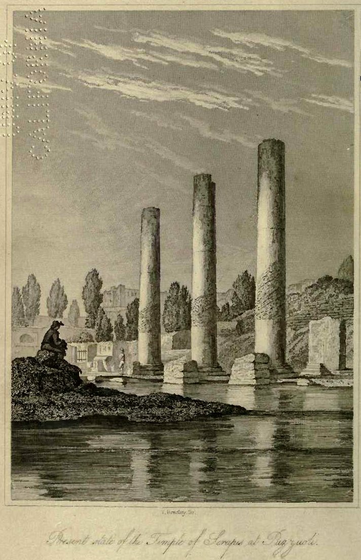
I visited Croatia a number of years ago after diving on some of the submerged Roman sites in Greece and seeing the Temple of Serapis in Naples (https://upload.wikimedia.org/wikipedia/commons/9/9e/Charles_Lyell_-_Pillars_of_Pozzuoli.jpg) . The temple is geologically infamous as the front piece to Charles Lyell’s seminal work The Principals of Geology where he notes the mark of marine boring organisms at some height up the columns thus indicating that they were once submerged.  He correctly interprets this as representing tectonic movements that have caused both a submergence and subsequent re-emergence of the temple since its construction in the late first to early second century AD. Contemplating the potential for drowned landscape reconstructions around the Mediterranean and Adriatic seas I briefly looked for papers describing sea level changes.  These were almost entirely absent from the academic literature.  Fast-forward to 2023 and I am here on the invite of Dr Simon Fitch (Bradford University) as part of his Future Leaders project. The idea is to map paleo-landscape surfaces in the many rias (drowned river valleys) along the Adriatic eastern shore. 

Split, Croatia
The project in Croatia is partnered with Dr Vedran Barbarić at the Faculty of Humanities and Social Sciences, University of Split and the first trial survey was undertaken on board the Pram, expertly skippered by the enthusiastic and knowledgeable captain Jerko Macura . For the acquisition we had chosen to use an Innomar Quattro parametric sonar (https://www.innomar.com/products/multi-transducer/quattro-sbp).  This hull-mounted sonar is configurable as either a line of four transducers emitting separate signals for high-resolution 3D type survey or as a block of four transducers working together for greater power and thus sea floor penetration.  The unit was side-mounted together with a Novatel IMU GNSS unit to provide heave corrections.  

Innomar Quatro with Novatel dual antenna motion reference unit

Over the course of 5 days we surveyed a number of small bays, outlets to the main large bays, channel crossings and both large and small deltas.

The weather cooperated for the most part until the Bora winds (a sever katabatic northerly wind from the shore) stopped play on our last day. The survey exceeded our expectations with penetration to greater than 15m sub-bottom in water depths up to 70m deep.  The seismic reflectors and character demonstrated sequences that could be interpreted as eroded bedrock, basin sediment infill, channel cuts, deltaic progression with periods of both regression and transgression. 

Channel entrance to the old harbour of Split

The potential for mapping multiple palaeo-landscapes and associated environments is huge. We now need a program to accomplish this that has ground truth from coring and careful modelling.  The project has only just begun so here is looking forward to returning and working with a great team.


Friday, 23 September 2022

Electric storms and digital stones: technology reveals the hidden secrets of stone circles on the Isle of Lewis

 Calanis - Beneath the Peat 2019-2020


Over the past few years we have been going to the Calanais site in Lewis, Scotland to try to map parts of the Neolithic landscape that are hidden today.  Rolling back the clock to over 5000yrs ago means that we have to consider significant changes in the landscape that include agricultural practice and natural changes such as the prolific growth of peat across the islands.  Further, there are have been changes associated with coastal position following the rise in sea level to present day heights. The Calanais Virtual Reconstruction Project is a joint venture led by the University of St Andrews with the Calanais Visitor Centre and the University of Bradford. The project team has been surveying the satellite sites near the Tursachan, the main prehistoric stone circle at Calanais. The surveys have revealed evidence for lost stone circles, buried beneath the peat and we have also used this data to create digital reconstructions that will allow visitors to virtually “walk” around the stones.

One rarely visited site surveyed known as Site XI or Airigh na Beinne Bige, consists of a single stone on an exposed hillside overlooking the whole valley and a couple of kilometres directly north of the Tursachan.  At the site we conducted a range of geophysics including electromagnetic ground conductivity mapping, electrical resistivity tomography, surface resistivity, magnetic gradiometry, and also used handheld magnetic susceptibility sensors to measure both the upstanding stone and to take measurements on the local rock exposures. The magnetic gradiometry revealed that the single stone was originally part of a circle of standing stones but that many of these are now buried by the thick peat deposits.


Magnetometry data at Site XI. Red columns indicate features interpreted as the position of lost stones. At the centre of the rough circle of smaller anomalies is a massive, star shaped feature which has resulted from a historic lightning strike

The gradiometry also revealed a very unexpected result – that of a star-shaped magnetic pattern right at the heart of the stone circle. This massive, star-shaped magnetic anomaly in the centre of the circle we believe to be the result of a single, large lighting strike or many smaller strikes on the same spot.

Such clear evidence for lightning strikes is extremely rare in the UK and the association with this stone circle is unlikely to be coincidental. Whether the lightning at Site XI focused on a tree or rock which is no longer there, or the monument itself attracted strikes, is uncertain. However, this remarkable evidence suggests that the forces of nature could have been intimately linked with everyday life and beliefs of the early farming communities on the island.

The project is now studying more archaeological sites in the area around the Tursachan, the main stone circle at Calanais. There are at least a dozen stone circles in the area, but at many sites the stones have fallen and become buried beneath the blanket peat that covers much of the landscape over the millennia. 

A view of the 3D model created by the computer science team at the University of St Andrews under Dr Alan Miller can be seen at https://vimeo.com/273858929.

At site X, also known as Na Dromannan the fallen stones sit on a hill overlooking the main valley.  Here careful scanning of the stones allowed a full 3D model of the site to be built. The virtual recreation allows the passage of the sun and moon around this circle to be tracked for the first time in four millennia. Now, anyone can virtually visit this remote site and get a real sense of what it was like just after it had been constructed. 

You can read a full account of the geophysics is given here:

Geophysical investigation of the Neolithic Calanais landscape Bates, C. R., Bates, M., Gaffney, C., Gaffney, V. & Raub, T. D., 11 Dec 2019, In: Remote Sensing. 11, 24, 2975.

https://www.mdpi.com/2072-4292/11/24/2975

Thursday, 22 September 2022

Durrington Pits – monumental structures in the Stonehenge landscape 2020

The pandemic provided some unusual opportunities and for me this was especially marked in the Stonehenge landscape by the absence of hordes of visitors.  This allowed a reuniting of brothers in survey, Vince and Chris Gaffney from Bradford University together with my brother, Martin from University of Trinity St Davids. We were joined in our field campaign by Eamonn Baldwin from Birmingham and my colleague Tim Kinnaird from St Andrews. The focus of our attention was a series of curious features seen on the magnetic gradiometer survey data. The features were evident as over 20 separate 10-20m diameter circles arranged in a concentric pattern around the Durrington Walls.  Fieldwork and analysis revealed evidence suggesting that they were massive shafts, measuring more than 5 metres deep. The circle formed by the shafts encloses an area greater than 3 square kilometres around the Durrington Walls henge, itself one of Britain’s largest henge monuments, and the famous, smaller prehistoric circle at Woodhenge.

Figure 1. Shaft locations surrounding Durrington Walls.

 Geophysical investigations included electromagnetic ground conductivity surveys, magnetic gradiometer, ground penetrating radar and electrical resistivity tomography.  The results of ground penetrating radar as a series of time slices are show in in figure 2.


Figure 2 Anomaly 8A – 250MHz antenna: Ground penetrating radar time slices at 10cm depth intervals, decreasing L–R from ground surface (top left) down to approximately 3.3m depth (bottom right).

Coring of the shafts provided radiocarbon and Optically Stimulated Luminescence dates suggesting these features are Neolithic and were excavated more than 4500 years ago, around the time that Durrington Walls was constructed.  The shafts may have served as a boundary to a sacred area or precinct associated with the henge. The Neolithic period, which is associated with the first farmers in Britain, is characterised by the development of ornate, and occasionally very large, rituals structures and enclosures, including the great stone circle at Stonehenge. However, no comparative prehistoric structure in the UK encloses such a large area as the circle of shafts at Durrington, and the structure is currently unique. 


Figure 3. Coring the sites with a mini-percussion corer

Aside from the scale of the structure, the circuit of shafts has other surprising characteristics. The boundary appears to have been deliberately laid out to include an earlier prehistoric monument within the boundary - the Larkhill Causewayed Enclosure. This site was built more than 1500 years before the henge at Durrington. This distance between the henge and earlier enclosure, more than 800 metres, seems to guide the placement of shafts around Durrington.  The evidence for how these pits were laid out is extremely important as it implies that the early inhabitants of Britain used a tally or counting system to track pacing across long distances (Figure 4).  Evidence for such careful planning, at such a scale, is unexpected at such an early period and emphasises how important the positioning of these pits was.


Figure 4. Least cost pathway analysis showing the use of pacing to mark out location of the pits.  They are further distance away down slope than parallel to slope

Archaeologists believe the effort invested in the great circle inscribed by the pits reflects an important  cosmological link between these two ritual sites, and that the large shafts were dug to record what must have been an important, sacred boundary.  The presence of these massive pits, and perhaps an internal post line, guided people towards the religious sites within the circle or even warned those who were not permitted to cross the boundary marked by the shafts.

Research on the pits at Durrington was undertaken by a consortium of archaeologists led by the University of Bradford as part of the Stonehenge Hidden landscape Project, and with the Ludwig Boltzmann Institute for Archaeological Prospection and Virtual Archaeology, the universities of Birmingham, St Andrews, Warwick, Trinity Saint David (university of Wales), and the Scottish Universities Environmental Research Centre (University of Glasgow).


Animation illustrating the landscape setting of the Durrington pit group, major monuments and the average distance from Durrington Walls to identified features as a line.

© Crown copyright and database rights 2013 (OS Profile DTM Scale 1:10000); EDINA Digimap Ordnance Survey Service (100025252) http://digimap.edina.ac.uk

To read more on this project:

Gaffney, V. et al. 2020 A Massive, Late Neolithic Pit Structure associated with Durrington Walls Henge, Internet Archaeology 55

https://intarch.ac.uk/journal/issue55/4/index.html


Notes

The universities undertaking field research supporting this press release included the University of Bradford with the Ludwig Boltzmann Institute for Archaeological Prospection and Virtual Archaeology the universities of Birmingham, St Andrews, Trinity Saint David (University of Wales), Warwick,, and the Scottish Universities Environmental Research Centre.  The work was undertaken a part of the Stonehenge Hidden Landscapes Project and brought together experts in non-invasive geophysical prospection and remote sensing, and specialists in British prehistory and landscape archaeology in order to carry out research in one of the most important archaeological landscapes  in Europe. The outstanding geophysical survey and visualization capabilities of the team has been made possible only because of the unique expertise and combined resources of the wider project partnership. an international collaboration of the Ludwig Boltzmann Gesellschaft (Austria), Amt der NiederösterreichischenLandesregierung (Austria),the University of Vienna (Austria), the Vienna University of Technology (Austria), ZAMG– the Central Institute for Meteorology and Geodynamics (Austria), Airborne Technologies (Austria), 7reasons (Austria), ÖAW– Austrian Academy of Sciences (Austria), ÖAI – Austrian Archaeological Institute (Austria), RGZM Mainz – Römisch‐GermanischesZentralmuseum Mainz (Germany), the University of Birmingham in collaboration with the University of Bradford (GB), Arkeologerna of StatensHistoriskaMuseer (Sweden), NIKU – Norwegian Institute for Cultural Heritage (Norway), and Vestfold fylkeskommune – Kulturarv (Norway).


Playing catchup - Summary of projets 2019-2022

Finally catching up

I think that all of us are feeling like we have a couple of lost years behind us but now are trying to play catch up with so many projects and parts of our lives.  For me, some of the research was put on temporary hold, some continued and parts of the time was spent writing up projects that were way-overdue in being published.  For the published work then this should gradually be coming out over the next few months and can be seen through my Uni web pages.  For the rest, then I will make up for it with a sting of blog summaries of what has been going on.

2019

Stonehenge - Durrington Pits

Calanais Lightning Strike

Armenia more lightning strikes and stone circles

2020

Fife Coast - reconstructing past climate

Tanzania Music - musicalising heritage

Viking Orkney - navigation pathways through the Orkney Isles

2021

Stonehenge and Durrington Pits

Uganda - exploration into new heritage territory

Greenland Humboldt glacier revisited

Tanzania - Hominid Footprints

2022

Antarctica - multibeam for climate action

Tuscany - demise of an Etruscan site in central Italy

Great Lakes - multibeam for wreck hunting


Curious Travellers: rebuilding the past through citizen science - 2019-2020

This work was summarised for my by Jamie Locke-Jones @ the Research Impact Office, University of St Andrews

Those who try to understand the past rarely have the luxury of complete records that detail the lives of our ancestors. Instead, history is often reconstructed through the fragments of evidence that have survived the ravages of time. Today, around the world, this tangible heritage, which includes buildings, monuments, and objects, is crumbling to ruin due to natural disasters and climate change. In 2018, following the bombing of Palmyra by the terrorist organisation Islamic State, Professor Richard Bates from the School of Earth & Environmental Sciences worked with colleagues at Bradford University and Durham University to initiate a citizen-science project to crowdsource images of the lost sites to document and digitally recreate them. The project grew to consider other threatened and damaged archaeological sites, from those impacted by earthquakes in Nepal to sites closer to home such as Yorkshire’s Fountain Abbey, which was suffering from the impacts of climate change.

Reconstructing Heritage 

Their website, Curious Travellers, operates as a piece of crowdsourced infrastructure, receiving photographs and videos donated by the public while also scouring the internet for additional fragments of information. The Curious Travellers team then combines these various data sources to create 3D representations of monuments and ancient sites that can be accessed online. One example is the Temple of Bel, Palmyra, Syria, which was dedicated almost 2,000 years ago in AD 32. Its ruins were thought to be the best-preserved in the whole of Palmyra, an ancient city dating back to the Neolithic period, before they were mostly destroyed by terrorists in 2015. The digitally reconstructed version, which can be seen below, has been painstakingly rebuilt from over 700 images found online and donated by members of the public. In this way, the monument can be seen authentically, without artistic license or academic guesswork. While still incomplete, the Curious Travellers reconstruction gives would-be visitors permanent way to see the Temple in its most complete and authentic possible state.  

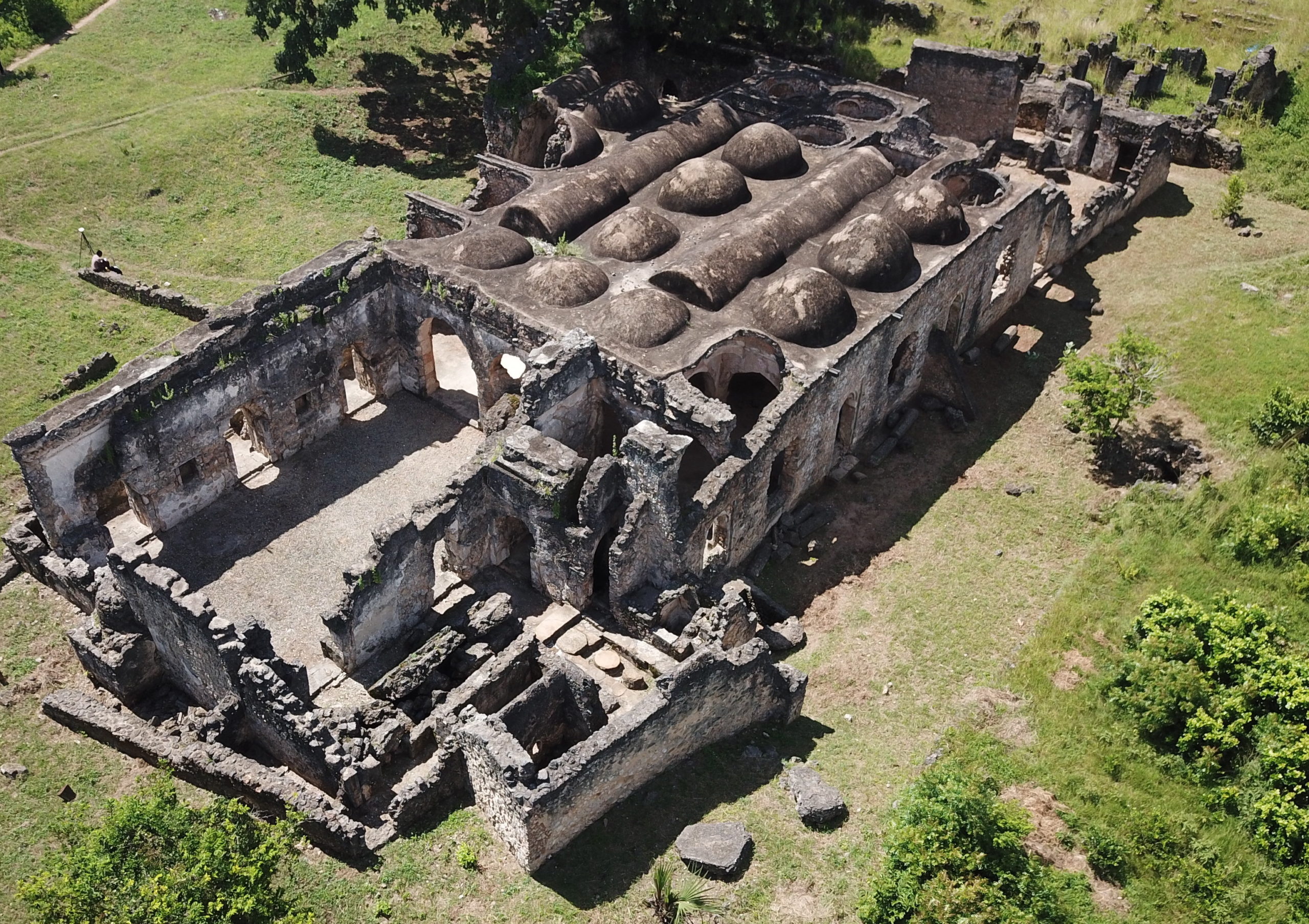
Building upon this work, the Curious Travellers team has moved on to acquiring data for other at-risk heritage sites such as Kilwa Kisiwani, a World Heritage Site in Tanzania. Here, working together with colleagues from the University of Dar es Salaam and the Tanzanian Department of Antiquities, the team has used ground-based and drone-based methods to document what remains to be seen at the site. Rising sea levels have flooded and eroded parts of the monument, and so work has also focused on exploring and documenting what can be found below the water. The resulting data has been used by the Government of Tanzania as part of a new Digital Heritage Database, created by the team specifically for the long-term management of their national heritage. Together with its Malawi counterpart, the Digital Heritage Databases are the first of their kind in the world, recording over 300 sites not previously documented in one place such as the World Heritage Sites Kilwa Kisiwan in Tanzania and the Chongoni Rock-Art Area in Malawi. 

Bates’ research initially focused on using geophysical sensing techniques to record and then reconstruct tangible heritage. This included land-based, airborne and marine-based systems, and development of these techniques allowed for their use at a range of scales, from recording individual buildings to whole landscapes. However, people’s lives extend beyond their tangible possessions, and our understanding of heritage has expanded over time to include the intangible culture that often provide meaning to what we can physically touch and see. With their models crowdsourced from photos taken by their namesake, Curious Travellers demonstrates how, without cultural meaning, even the most imposing temple can fade from memory.  Intangible heritage is now being actively recorded by the team, with stories, songs, cultural practices and ways of life all finding invaluable preservation in the Digital Heritage Database. 

The impact of heritage protection goes beyond an enhancement of our archaeological knowledge. By recreating cultural monuments that were destroyed due to conflict or other factors, Bates and the Curious Travellers team are rebuilding a sense of heritage within communities around the world. Cultural sites are directly linked to cultural identity and familiarity; to preserve these sites, even digitally, is to embrace their community’s history and celebrate the culture of societies that might otherwise be forgotten.  


This work contributed to the University of St Andrews’ REF 2021 submission.

The Research Excellence Framework (REF) is a system which assesses research at UK Higher Education Institutions by discipline, based on three elements: outputs, impact and environment. This blogpost is based upon an impact case study that contributed to St Andrews’ outstanding results this REF cycle. Visit REF to view the submitted case study in the UKRI’s impact case study database.