Showing posts with label palaeolandscape. Show all posts

Wednesday, 5 April 2023

Croatia 2023

 The drowned landscapes off Croatia

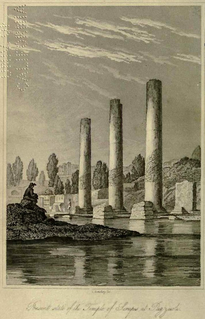
I visited Croatia a number of years ago after diving on some of the submerged Roman sites in Greece and seeing the Temple of Serapis in Naples (https://upload.wikimedia.org/wikipedia/commons/9/9e/Charles_Lyell_-_Pillars_of_Pozzuoli.jpg) . The temple is geologically infamous as the front piece to Charles Lyell’s seminal work The Principals of Geology where he notes the mark of marine boring organisms at some height up the columns thus indicating that they were once submerged.  He correctly interprets this as representing tectonic movements that have caused both a submergence and subsequent re-emergence of the temple since its construction in the late first to early second century AD. Contemplating the potential for drowned landscape reconstructions around the Mediterranean and Adriatic seas I briefly looked for papers describing sea level changes.  These were almost entirely absent from the academic literature.  Fast-forward to 2023 and I am here on the invite of Dr Simon Fitch (Bradford University) as part of his Future Leaders project. The idea is to map paleo-landscape surfaces in the many rias (drowned river valleys) along the Adriatic eastern shore. 

Split, Croatia
The project in Croatia is partnered with Dr Vedran Barbarić at the Faculty of Humanities and Social Sciences, University of Split and the first trial survey was undertaken on board the Pram, expertly skippered by the enthusiastic and knowledgeable captain Jerko Macura . For the acquisition we had chosen to use an Innomar Quattro parametric sonar (https://www.innomar.com/products/multi-transducer/quattro-sbp).  This hull-mounted sonar is configurable as either a line of four transducers emitting separate signals for high-resolution 3D type survey or as a block of four transducers working together for greater power and thus sea floor penetration.  The unit was side-mounted together with a Novatel IMU GNSS unit to provide heave corrections.  

Innomar Quatro with Novatel dual antenna motion reference unit

Over the course of 5 days we surveyed a number of small bays, outlets to the main large bays, channel crossings and both large and small deltas.

The weather cooperated for the most part until the Bora winds (a sever katabatic northerly wind from the shore) stopped play on our last day. The survey exceeded our expectations with penetration to greater than 15m sub-bottom in water depths up to 70m deep.  The seismic reflectors and character demonstrated sequences that could be interpreted as eroded bedrock, basin sediment infill, channel cuts, deltaic progression with periods of both regression and transgression. 

Channel entrance to the old harbour of Split

The potential for mapping multiple palaeo-landscapes and associated environments is huge. We now need a program to accomplish this that has ground truth from coring and careful modelling.  The project has only just begun so here is looking forward to returning and working with a great team.


Thursday, 1 March 2018

Irish Sea Cruise

So if you follow what we have been doing on the Lost Landscapes front over the last couple of years you will know that we have a large programme of work on reconstructing “lost”, submerged and buried landscapes around the world’s continetnatl margins.  The Lost Landscapes project is one of the core elements of this programme and is an EU-funded project based around reconstructions in the North Sea across what has been termed Dogger Land. A recent addition to this project has been an extension into the Irish Sea and specifically in Liverpool Bay and Cardigan Bay off the Welsh coast.  Liverpool Bay was the focus of work a few years ago before the large windfarms were constructed and has been written up in a series of reports and books (see Fitch and Gaffney, 2011 for example). I will leave this for a later discussion.


Cardigan Bay has of course always been of interest to me growing up in Aberystwyth - swimming at Clarach, walking the coastline to Aberaeron and New Quay and playing in the dunes of Ynys Las.  More recently I have also been doing some work with my brother and father on the submerged forests at Borth.  Throughout my childhood I remember walks to see the forest of stumps that are periodically exposed after storms rip in from the Atlantic on this stretch of Welsh coast.  Over the last few years they have been exceptionally well exposed as there have been various engineering works going on along the shore for protection measures.  Back in February 2012 while my parents were taking one of their usual “what’s going on?” walks my father noticed blackened and shattered stones amongst the stumps which my brother later identified as burnt cooking stones.  This led to a series of projects investigating the site that yielded not only some well-preserved animal foot prints but the most impressive set of ancient red deer antlers (dated to 2940+/-30 B.P.)  that I have ever seen!  We did some geophysics (resistivity imaging and electromagnetics) on the beach which was published in 2016 (Bates and Bates, 2016). The forest here is dated to Bronze age but the deposits extend under the beach and offshore.  It is these earlier deposits that we were attempting to target with the current survey.  Specifically we hoped to be able to map the Mesolithic landscape and acquire material from that time period for environmental analysis including DNA sequencing. 
Borth fossil forest - photo D. Bates

To survey kilometres offshore and get core material through potentially metres of modern marine muds requires large survey vessels.  Thankfully a collaboration with colleagues at UCC (Dr Ben Geary) and IT Sligo (Dr James Bonsall) gave us access to a week on the Celtic Explorer.  This vessel is operated by the Marine Institute, Ireland and is equipped with all the tools of the trade including multibeam sonar, sub-bottom sonar, sidescan sonar, and both vibro-corer and gravity corer!  Lots of TOYS!!!  (For a link to these jump to the end of this blog)

After some initial set-backs with logistics the Voyager crossed the Irish Sea up to Liverpool Bay.  A night of geophysics yielded a number of target spots for the coring.  Here the previous work greatly aided us in picking target sites but the overlying sand proved too much of a challenge for the 3m vibrocorer.  So on to Cardigan Bay.

Background work for Cardigan Bay is a lot more sketchy than up north with most of the previous surveys collected back in the late 70s for speculative oil and gas exploration.  Our first task was once again to gather information from the geophysics.  The subbottom profiler on the Voyager is a two by two pot pinger.  Usually I would be a little sceptical of these for giving any great penetration of the seafloor however this setup has completely made me re-evaluate that.  From the first we started to see small channels buried a few metres beneath the present day seafloor that cross cut what appeared to be a glacial till horizon. Till is the material that is left as a result of ice retreat and so tells us about conditions during these cold periods of history.  The last cold (glaciation) period had its maximum about 27,000yrs ago (Clark et al., 2009) with ice reaching far down the Irish Sea and covering the Welsh landscape.  Draining the ice sheets would have been rivers that flowed across a barren plain in front of the sheets.  Because of the ice global sea level was much lower than today by up to 120m and so this part of Cardigan Bay would have been land following glacial retreat.  Where the rivers coalesced large channels formed which cut deep into the till as the climate became warmer.  By the Mesolithic, it was these landscapes criss-crossed by the rivers that people would have migrated back into before they became covered by the rising sea. 

Some modelling work that I had done a few years ago was used to test where the rivers had once flowed and it proved remarkably insightful.  The extent of the deep erosion of rivers however was something that totally blew us away!  Channels 20-30m deep contain multiple fill events suggesting a complex drainage history to the Welsh landscape.  There is clearly a stunning story to be pulled out of this area that will need a lot more geophysics to understand.  We will also need a lot more coring as our attempts at this proved not as successful as the geophysics due to drift of the boat in the currents and wind.  The cores that were taken will now go back with my brother to his lab for analysis and we hope to return to the site next summer for more geophysics and coring.  Ultimately these core will be examined for a whole range of environmental signatures including some DNA analysis that could potentially reveal what the landscape was like and what or who might have inhabited it!
Channel offshore Aberaeron


The Celtic Voyager and willing crew made the cruise a real pleasure, though I am going to have to go on a serious diet – how the crew do this month after month is beyond me or would be beyond my will power when it came to meal times!

This project is part of the Lost Frontiers EU research grant led by Prof Vince Gaffney at Bradford University.

Multibeam sonar -  Konsberg EM2040 
Pinger - SES500 Geopulse
Sidescan sonar - Edgetech 4200


Bates, C. R. and Bates, M. R. 2016. Palaeogeographic Reconstruction in the Transition Zone: The Role of Geophysical Forward Modelling in Ground Investigation Surveys. Archaeological Prospection, v. 23, pp. 311-323
Clark, et al., 2009. The Last Glacial Maximum. Science, v325. 710-4. 10.1126/science.1172873
Fitch, S and Gaffney, S. 2011. West Coast Palaeolandscape Survey


Monday, 30 May 2016

AUV hits Orkney

In the week of large scale remembrances of the Battle of Jutland that will include amassing parts of the British Naval Fleet, the German Fleet and possibly parts of the Danish fleet we made our own bit of history by testing for the first time one of the new generation of survey vehicles the Gavia AUV in the waters of Orkney.  The Gavia (Teledyn, Iceland) Autonomous Underwater Vehicle is a type of propelled platform designed to deploy geophysical instruments for survey beneath sea.  The vehicle looks like a small torpedo and in our configuration has onboard a complex navigation system, sidescan-bathymetric sonar and a high resolution camera.  The sonar is used to map the seafloor and to obtain backscatter images of the features on the seafloor.  The camera can likewise be used to identify seafloor features and to mosaic complete maps of what is there. There are two big advantages of using AUVs over conventional surface-based survey methods.  The first is that by flying an AUV beneath the surface it will not be affected by the noise and motion of waves and thus be able to “fly” in a steadier manner.  The second is that it can be pre-programmed for the survey and launched from either a boat or the shore.  With a forward looking sonar onbaord for collision avoidance the AUV does all the work while you sit back and have a cup of coffee – at least that is what should happen in theory!


The AUV (named “Freya”) was brought to the site by a team from the Scottish Association for Marine Science out of Dunstaffnage (SAMS) and was part of a small grant awarded to us by the Marine Alliance for Science and Technology Scotland (MASTS).  For John Howe, Karen Wilson and Colin Abernethy it was a first for not only visiting Orkney but also for using the AUV on an archaeological project.   Time was split between surveying the loch of Harray, near to the Ring of Brodgar and Ness of Brodgar archaeological sites and surveying in the Bay of Firth close to areas where we have previously mapped and reported unusual features on the sea floor.


Context
The Rising Tides project has been investigating the area around the Ring of Brodgar for a number of years.  Most recently we have completed a full bathymetry and sub-bottom sonar survey of the loch of Stenness to the west.  The purpose of this work was to reconstruct the palaeo-landscapes and environments when the Ring of Brodgar and Ness of Brodgar were being built and used. What our work demonstrates is that the loch was smaller at that time and further that there was a complex history of sealevel rise associated with the infilling of sediments with a step change in sediment input coincident with changes in vegetation in the catchment at about 6ka BP. For more details on this see our publication “The environmentalcontext of the Neolithic monuments on the Brodgar Isthmus, Mainland, Orkney

Caroline and I have also been experimenting with digital reconstructions for the area that can be seen on our test site "Ancient Lands

AUV in the Loch of Harray
In order to match the work in the loch of Stenness we brought the AUV to the loch of Harray.  This loch is a shallow, freshwater loch to the east of the Brodgar isthmus.  Previous surveying with the sub-bottom profiler showed it to not only very shallow at the southern end (less than 4m water depth), but also that the sediments were gas saturated for the most part.  Because of the very shallow water the AUV was not able to “fly” beneath the water and had to be operated as a surface vehicle.  This, combined with the fresh water challenged both the vehicle and the operations team to come up with novel ways of ensuring the AUV did not either crash into the bottom or into any of the small fishing vessels on site! Unfortunately, the weather also proved problematic with strong winds.  The vehicle was able to survey a few lines of data but the automated tracking features did not work correctly and so the vehicle did not manage to stay on course in order to survey a complete grid of data.

AUV in Bay of Firth
Following the tests in Harray (also useful because it was a confined loch and so there was no chance of the AUV being lost out to sea!) we took Freya to the Bay of Firth.  Here she was much more at home back in saltwater and also with a greater depth range to work in (up to 9m water depth).  A survey grid was programmed in the centre of the bay over areas where we have previously recorded and dived on unusual stone features.  Freya was deployed from a small rib and perfectly performed her planned mission of bathymetry mapping, sidescan sonar imaging and photography.  The preliminary results, processed within minutes of return to shore (another huge advantage over old methods of survey) showed a resolution that we had not seen before.  Fantastic new images of the seafloor which we will now ponder over before our return to dive on them in August.  Look out for results in a later post.
The AUV opens up a new era for us with archaeological survey.  There are so many sites that could benefit from this type of survey and many new and exciting discoveries to be made.
The AUV team with Richard and Caroline in Orkney - check out the renewable power sources!

 PS – on a historic note, the Gavia is approximately half the size (half the length and diameter) of the original WW I torpedoes and weighs about the same as the explosive head that these carried

Wednesday, 10 December 2014

Sanday, Orkney Core Sampling

The Storm Chasers are Back!

Actually the Rising Tides team are back up in Orkney, Sanday to be precise, trying to chase environmental signatures of the past while also trying to dodge a weather bomb!  So what is it we are actually doing and what is a weather bomb?  As those of you who have read any of our previous work will know we are particularly interested in understanding palaeo-environments, landscapes and geography in relation to past societies.  Our work on the mainland, that is the mainland of the Orkney Isles, has reconstructed drowned landscapes through geophysical, coring and diving work.  On Sanday, we have come chasing the records of a drowned forest.  Sounds familiar? Well yes, in some ways it is similar to those sites on the west coast of Wales, and from a much older time frame  the sites at Happisburgh where we found the oldest footprints outside Africa last year.  Here in Sanday however we are trying to link back to that critical period in the development of human behaviour, the change from hunter-gatherer in the Mesolithic to the farmers of the Neolithic.


So why Sanday? Well, for one reason that a “drowned” forest has been written about in the past. In 1867, in the History or Orkney the Rev George Barry reported a “strong tradition that the harbour of Otterswick in Sanday was once a forest, which was destroyed by inundation. “and further, a sample of the trees was obtained by Traill-Dennison in March 1890.  We walked the beaches here and ran some speculative geophysics last summer with encouraging results that led us to a bay on the west coast of Sanday where with great luck on a particularly low tide we spotted a small raft of peat.  Coring and measurement of its elevation confirmed that it was equivalent to the Otterswick Bay samples and so here we are, back again on a series of very low spring tides to get further samples. 


So what’s the problem? It’s December, there is limited daylight here and we have the “storm of the century” approaching (think The Perfect Storm)!  The task therefore is to get some samples and undertake some more geophysics before it hits.  The tactics – geophysics (always geophysics) but most importantly some serious extreme geoscience sampling – a JCB! (for those of you who are not familiar with this great vehicle, and actually its not a JCB that we are using, then it’s a backhoe).
The results – instant sections, great samples and all done before today with its horizontal sleet and snow.  We have now dug four test pits (typically in fading light at low tide, actually it was dark!) and found the peat.  Significantly the peat we have dug appears to be full of freshwater molluscs at the base but towards the top there are articulated marine bivalves as well as whelks and other marine molluscs.  This is what we are after – it documents the onset of marine conditions and allows us to begin to understand how marine waters flooded across these Mesolithic landscapes.  Elsewhere we have been augering in probable infilled bays where we discovered more than 2.5m of peats and sands alternating throughout the core.  This documents the interaction between the land and the sea and excitingly these cores are very close to a multi-period archaeological site that started in the Neolithic and continued intermittently until the Viking period.  So mission accomplished so far….watch this space


Sunday, 16 February 2014

Kilwa Marine Geophysics Survey, 2014

I have just returned from Tanzania working with Dr Ted Pollard from the British Institute in Eastern Africa and Elgidius Ichumbaki from the University of Dar es Salaam. Ted (also an honorary researcher at St Andrews) has been researching coastal archaeological sites along the southern Tanzanian islands near World Heritage site of Kilwa for over 10years.  His studies have documented settlements and trade back to Middle Stone Age with extensive developments from the 14C and 15C based on gold trade  that originated in modern Zimbabwe. To date, most of his work has been focused around recording intertidal sites in relation to the changing geomorphology that will have dictated the land use.  He has shown how river channels and harbours have silted up, settlements abandoned both as a result of nature and from human pressure.  There is a fascinating story in this coast line and one that despite the obvious immediate differences (its hot and the water is warm) has many similarities to the work that many of us are conducting around the North Sea.  

Kilwa Fort, Kilwa World Heritage Site, Tanzania


So this year Ted wanted to investigate the sub-tidal part of the study area.  In order to do this I have brought out our SwathPlus 468kHz bathymetric sidescan.  This is the sonar that we have been using up in Orkney, Scotland (see earlier posts) to successfully map the submerged topography (the drowned landscape) but also using to map different types of biological habitat on the seafloor.  It was deployed with a TSS DMS205 motion reference unit, sound velocity probe, Vector Hemisphere GPS and Topcon RTK dGPS.  Unfortunately here I do not have the advantage of bringing a custom survey vessel so we are relying on the collaboration with the Tanzanian Antiquities Department.  Check the video clip to see how the survey went and get a feel for the place. The boat required a fair amount of impromptu rigging and a couple of visits to a local woodworking shop - here my demands on yokes to go around the keel of a boat were a welcome change from making bed frames I think.

Charles Okeny from BIEA surveying using the SwathPlus bathymetric sonar
Over the course of the two weeks we managed to get a fair amount of the inner harbours covered including some great detail around the old fort and palace. Water depths ranged down to 65m and from the mapping it appears that there are a number of submerged coral terraces plus some great sediment features. 

As with any geophysics, it is only as good as the ground truth and so there was nothing for it here but to jump into the water to get some.  Whereas I am usually a fan of putting down an ROV (remotely operated camera) there was just not the facilities to do this and so we hired kit from a local dive centre and had to do the honourable thing – diving around coral reefs can be a hardship, honest!

The final map of bathymetry showing a deep (>60m) channel with steep coral shelf breaks


Dr Ted Pollard 
The result of the day of targeted dives proved out many of the sonar targets and gave some valuable information on seafloor type.  It also gave us the first confirmation of archaeological significance with a large pottery scatter at one site.  Ted will now be following this up with careful analysis/identification of the pottery.


Thursday, 30 January 2014

La Cotte de St Brelade


From Feb to Sept 2014 a new exhibit will be on show at the Natural History Museum, London that highlights some of the research undertaken by scientist in St Andrews and elsewhere in the UK as part of the Ancient Human Occupation of Britain project over the last 10years.  Britain: One Million Years of the Human Story presents key material and evidence from a number of important sites in and around the UK that help to document the dramatic story of changing landscapes and the people who lived in them over the last million years.  Two of the sites that this major exhibition showcases have been the focus of research for the dept E&E over the last 5years.  La Cotte de St Brelade is briefly described here, Happisburgh has been presented in a previous blog and will be the focus of a future blog as new results are published.


La Cotte from the sea

La Cotte de St Brelade in Jersey is a cave site that contains a 250kyr record of human use.  Investigations have been conducted at the site over the last 100yrs but there still remains much material that has yet to be uncovered.  It’s position however, on the shore in a highly vulnerable situation, means that much of the material is in danger of being lost forever and the site has been subject to intense recent study under a NERC emergency project.


A geophysical programme was initiated in 2012 to survey the wider palaeo-environmental context of the site.  This included high resolution marine mapping combined with geophysical modelling to allow the archaeologists to drain away the sea and literally step back in time to walk through the ancient landscapes. 


The palaeolandscape was surveyed using multibeam sonar aboard two research vessels, a 15m research yacht, Gambo and also using my inshore craft, the zego boat.  The resulting landscape model shows a complex valley system offshore, through which the herds of game would have been forced along routes leading up to the dead-end valley infront of the cave site.


Watch as sea rises over the submerged landscape of eroded granite terrain and then fly over the valleys up to La Cotte to get a view looking out from the cave


The new views from the mammoth butchery cave site are providing alternate context for understanding the prolific finds that have been dug from the site over the last century. 


 Work continues at the site and in 2014 we hope to start exploring the relationships between landscape, geology and the geology of tool assemblages from the cave.